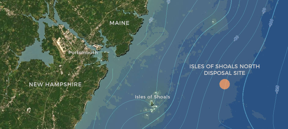
The Environmental Protection Agency (EPA) has designated an Ocean Dredged Material Disposal Site at Isles of Shoals North to serve Maine, New Hampshire, and the northern Massachusetts coastal region. The Isles of Shoals North Disposal Site (IOSN) is located approximately 10.8 nautical miles east of Portsmouth, New Hampshire.
The newly designated Ocean Dredged Material Disposal Site (orange circle) is located off the coast of New Hampshire and Maine. Lines indicate water depth contours. Launch interactive map
In September 2019, EPA released the Draft IOSN for public comment and worked with the Northeast Regional Ocean Council to post data and information about the proposed site on the Northeast Regional Ocean Data Portal. Materials included links to the Draft Environmental Assessment and Evaluation Study (Draft EA), as well as interactive versions of some of the maps in the Draft EA that included several datasets from the Northeast Ocean Data Portal. Those maps are still available for viewing in an archived Isles of Shoals North Disposal Site Map Gallery.
The comment period ended on October 18, 2019. EPA released the Final Rule and Final Environmental Assessment for Designation of an Ocean Dredged Material Disposal Site for the Southern Maine, New Hampshire, and Northern Massachusetts Coastal Region and Finding of No Significant Impact on September 25, 2020. The effective date for the Isles of Shoals North Ocean Dredged Material Disposal Site is October 26, 2020.
For more information:
- Visit the US EPA Isles of Shoals North Disposal Site
- Read the Final Rule in the Federal Register.
- Read the Final Environmental Assessment for the Designation of an Ocean Dredged Material Disposal Site in the Southern Maine, New Hampshire, and Northern Massachusetts Coastal Region and Finding of No Significant Impact.
- Read the Draft Environmental Assessment and Evaluation Study for Designation of an Ocean Dredged Material Disposal Site for the Southern Maine, New Hampshire, and Northern Massachusetts Coastal Region
- Visit the archived Isles of Shoals North Disposal Site Map Gallery


