Mar 27, 2025
Several new and updated seafloor datasets have been added to the Portal recently. Each comes from a different provider, but collectively they represent the robust state, federal, academic, and industry collaborations in the northeast U.S. around seafloor characterization.
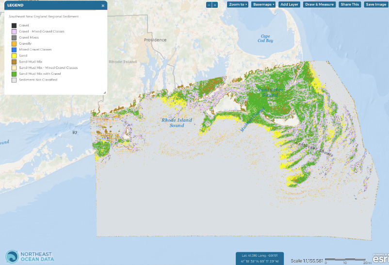
Southeast New England Regional Sediment Types
This dataset was recently published in the journal Geosciences (Capizzano et al. 2024; DOI: 10.3390/geosciences14070186) and displays the predicted occurrence of benthic sediment types off southern New England at very high resolution. Input data sources include regional bathymetric data from acoustic surveys and seafloor sediment data from in-situ sampling (i.e., photos, grabs, cores) from USGS, NOAA, University of Massachusetts – School of Marine Science and Technology (SMAST), and several offshore wind companies. This data product was created through the collaborative efforts of INSPIRE Environmental and the Northeast Regional Ocean Council (NROC) for the NROC Data Portal, with funding from the Massachusetts Clean Energy Center, Rhode Island Department of Environmental Management, and Bureau of Ocean Energy Management, to supplement existing regional benthic habitat datasets. Southern New England was selected as a study area due to the amount of publicly available data. The methodology used to create this dataset can be expanded as higher resolution bathymetric data become publicly available. Find the data under Bathymetry & Seafloor > Sediment Products in the Data Explorer.
Data Provider(s):
- National Oceanic and Atmospheric Administration (NOAA)
- US Geological Survey (USGS)
- University of Massachusetts – School of Marine Science and Technology (SMAST)
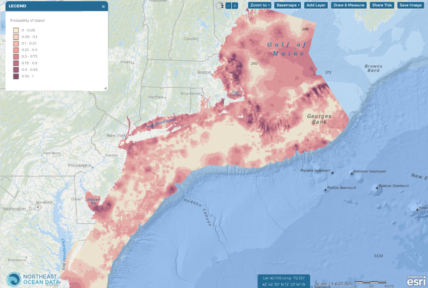
Surficial Substrates from Maine to Virginia (Stokesbury et al. 2024)
Six new data layers display the outputs of geostatistical models that estimate the probability of five geologic and one biogenic substrate types being present at a 250 m resolution. The models leveraged two large data sets: the University of Massachusetts – School for Marine Science and Technology (SMAST) drop camera survey (242,949 samples, 2003 to 2019) and the US Geological Survey databases (27,784 samples, 1966 to 2011), which were combined to derive sea floor surficial substrate probability maps for the Northeastern US continental shelf from Virginia Beach to the Gulf of Maine to 300 m depth (218,571 km^2). The modeling methods and results are presented in “Anticipating the winds of change: A baseline assessment of Northeastern US continental shelf surficial substrates”, published in the journal Fisheries Oceanography in 2024 by Kevin D.E. Stokesbury, N. David Bethoney, Felipe Restrepo, and Bradley P. Harris (https://doi.org/10.1111/fog.12693). Find the data under Bathymetry & Seafloor > Sediment Products in the Data Explorer.
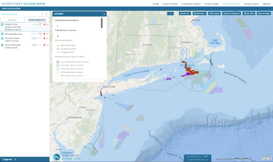
Relocated Boulders and Original and Final Boulder Locations
The Portal already contained a layer visualizing the point locations where boulders (usually defined as pieces of rock >256 millimeters or ~10 inches in diameter) on or within the seafloor were relocated during offshore wind projects including Vineyard Wind, South Fork Wind, and Revolution Wind. A new layer adds original and final locations of boulders associated with the construction of the Empire Wind 1 cable route (near the Verrazano Narrows in New York). The boulders marked on this layer from Empire Wind 1 are 1 meter (~39 inches) or greater in diameter and were moved at least 2 meters from their original location.